 Click here for a zoomable map and the Strava Route
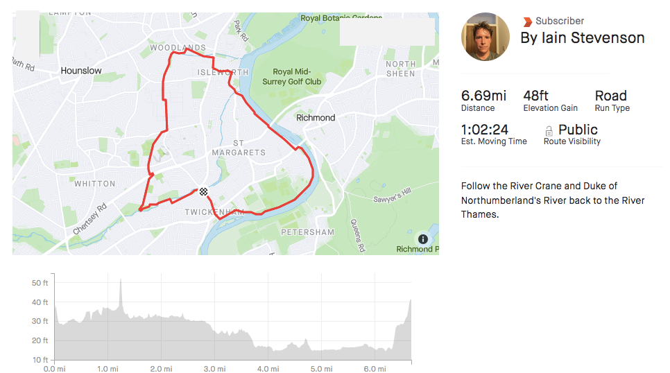
- Distance – 6.7 miles
- Surface –Tarmac paths
- Terrain – Flat
- Surroundings – Park, road, river
- Traffic Free – No (stretches of the route follow roads)
A 7-mile loop taking in the lesser know tributaries of the River Crane and Duke of Northumberland’s River cutting through the suburbs of Twickenham and Isleworth finishing on the meander from Richmond back to Twickenham.
The Route
Start – Twickenham Station
The route starts and finishes at Twickenham Station, but can be started anywhere along the route or added as part of an existing run.
Turn right out of the station, cross the road and drop down to the footpath down the River Crane. Follow the river for 0.5 miles.
0.5 miles – Craneford Way Playing Fields to Kellner Gardens (0.4 miles)
Cross the river at the footbridge over to Craneford Way Playing Fields, turn left and follow the fields, path and roads through Mereway Nature Reverse to Kellner Gardens.
1 mile – Kellner Gardens to Modgen Water Treatment Works (1 mile)
At this point, the River Crane meets the Duke of Northumberland’s River. Turn right and head north following the Duke of Northumberland’s River for 1 mile passing the Twickenham Stoop and Twickenham Stadium Rugby grounds. You will need to use the footbridge to cross the A316 Chertsey Road.
The path will come to an end. Turn right and cross the road. At the roundabout, head along the footpath to the left of the entrance to Modgen Water Treatment Works.
1.9 miles – Modgen WTW to Woodlands Road (0.9 miles)
Follow the river for nearly 1 mile crossing Worton Road where you also swap sides of the river, onto Woodlands Road.
2.8 miles – Head to the River Thames (1.1 miles)
Sadly you need to leave the river for a mile to weave eastwards through the streets to the River Thames.
4 miles – Isleworth along the Thames back to Twickenham (2.7 miles)
Once at the Thames, head upstream (south) tracking the river back to Twickenham, passing through Marble Hill Park.
Opening Times
The route has no opening and closing times. It’s not recommended to run on the route when it’s dark for safety reasons. Please note, the route also has some narrow sections with high fences on either side.
Getting There – Public Transport
The route starts and ends at Twickenham Station.
Parking
Paid parking is available in Twickenham. The Embankment next to the river near Diamond Jubilee Gardens (TW1 3SU) is a pleasant spot, but spaces are limited. Much of the on-street parking is resident only.
Food and Drink
The centres of Twickenham and Richmond have a myriad of coffee shops and eateries to pick up a snack or sit down for something more substantial.
Parkrun
There’s are two nearby parkruns every Saturday at 9 am at Old Deer Park and Richmond Park, where are both the other side of the River Thames to the route.
Other Attractions
Kew Gardens (Royal Botanical Gardens) and Richmond Park are both nearby.
Strava
Click here for the Strava route which you can print or export.